Glacier Collapse May Have Triggered Nepal Catastrophe as Satellite Images Reveal Enormous Ice-Rock Avalanche
What do the new satellite images show?
The Scar in the Himalayas
A catastrophic flood that tore through the Nepal–Tibet border region may have begun thousands of metres above the devastated villages, where new satellite imagery reveals an enormous collapse of ice and rock from a Himalayan glacier. Investigators are now examining whether that avalanche unleashed the deadly chain reaction that sent water, mud and boulders racing through narrow valleys below.
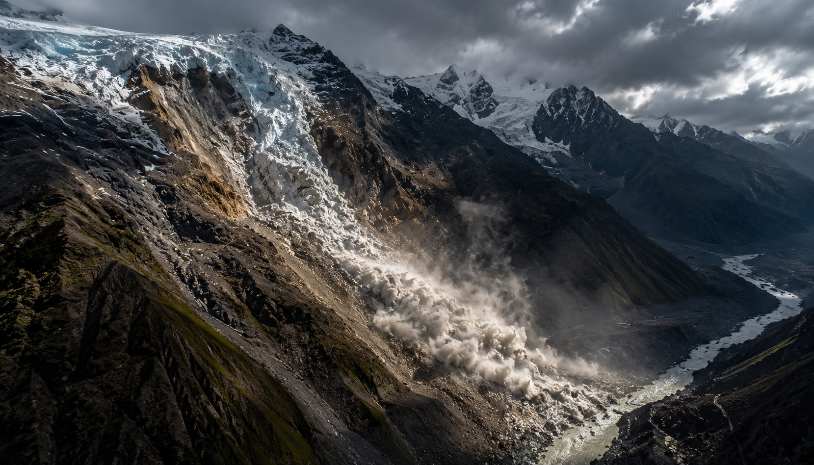
The discovery significantly changes the emerging picture of Wednesday's disaster. Rather than a conventional monsoon flash flood alone, scientists are investigating an extraordinary high-altitude event in which part of a glacier appears to have broken away at roughly 5,200 metres before plunging towards the valley floor.
Satellite Images Reveal Where the Disaster May Have Started
Before-and-after satellite imagery captured on August 25 and August 26 shows a striking disturbance in the mountains near the Nepal–China border. Planet Labs imagery has helped researchers identify the apparent source area, with fresh debris spreading down a steep Himalayan valley that looked dramatically different only a day earlier.
Preliminary analysis released through Nepal's disaster authorities identified an ice-rock landslide roughly 20 kilometres northeast of the Rasuwagadhi border crossing. The mass appears to have entered the Lhende Khola river system, potentially creating the first step in the destructive sequence that followed.
Independent landslide analysis has placed the apparent source at approximately 28.2765°N, 85.5194°E. The precise sequence remains under investigation, but the satellite evidence provides something rescuers did not have during the first chaotic hours of the disaster: a plausible geographical starting point.
The scale is extraordinary. Initial expert analysis indicates that the lower portion of a glacier may have detached at roughly 5,200 metres and fallen more than 1,200 metres into the valley below, carrying huge quantities of ice and rock with it.
How a Mountain Collapse Can Become a Catastrophic Flood
An ice-rock avalanche does not need to contain all the water eventually seen downstream. A collapsing mass can strike a river, entrain saturated sediment, melt or fragment ice, pick up loose material and temporarily block a narrow valley.
That temporary blockage is one of the leading possibilities being investigated. Kathmandu University climate researcher Rijan Bhakta Kayastha has said an initial assessment suggests the avalanche may have blocked the Lhende river, allowing water to accumulate before the obstruction failed and sent a sudden surge downstream.
Once moving through a steep Himalayan river system, such a surge can transform rapidly. Rock, mud, trees and sediment are added to the flow, dramatically increasing its destructive power while the confined valley gives the water few places to disperse.
That may help explain the extraordinary speed of Wednesday's disaster. Reports from the affected river system indicate water levels rose by as much as nine metres downstream within around half an hour as the surge moved through the Bhote Koshi and Trishuli systems.
The result was devastating. Homes, bridges, roads, border infrastructure and hydropower facilities were overwhelmed as the flood swept through the Rasuwa region and towards communities farther downstream. The catastrophe also crossed an international frontier, with serious destruction reported around Gyirong in Tibet.
The Earthquake Question Is Now Crucial
One mystery sits at the centre of the investigation: what caused the mountain to fail?
A magnitude 4.4 seismic event was recorded in Nepal at 02:52:48 UTC on August 26. Early official assessments raised the possibility that seismic shaking destabilised the glacier or surrounding rock immediately before the flood.
That would offer an apparently straightforward chain of events: earthquake, avalanche, river blockage, dam failure, catastrophic flood.
But scientists are already questioning whether the sequence was actually that simple.
Landslide expert Dave Petley has argued that the seismic signal interpreted as an earthquake could instead have been generated by the enormous rock-and-ice avalanche itself. In that interpretation, instruments detected the mountain collapsing rather than a tectonic earthquake triggering the collapse.
That distinction is important because the disaster's underlying cause changes depending on which sequence proves correct. If an earthquake destabilised an otherwise intact slope, this may primarily have been a seismic-triggered cascading disaster. If the mountain failed independently and generated the seismic signal itself, investigators must determine what caused such a vast mass of ice and rock to become unstable.
For now, neither explanation should be treated as conclusively established.
Where Did So Much Water Come From?
The volume and speed of the flood create another major scientific question.
If the originating event was primarily an avalanche rather than the sudden drainage of a large glacial lake, researchers must explain how a collapsing mass high in the mountains generated such a powerful downstream torrent.
Several mechanisms can operate simultaneously. Ice may fracture and partially melt during an enormous high-energy descent. The avalanche can pick up water already flowing through the river, entrain saturated sediment and incorporate snow and ice along its route. A temporary natural dam can then concentrate that material before suddenly releasing it.
Petley has suggested the water could therefore have come from a combination of ice affected during the collapse, moisture within entrained sediments and existing river water.
That makes the disaster potentially different from a classic glacial lake outburst flood, in which a lake held behind ice or moraine suddenly breaches. Scientists are still investigating whether a glacial lake nevertheless played some role in Wednesday's event.
The Human Toll Is Still Becoming Clear
The scientific investigation is unfolding alongside an enormous rescue operation.
By later Wednesday, at least 98 deaths had been reported across Nepal and China, including 95 in Nepal, while hundreds remained unaccounted for. More than 400 people, including hundreds of foreign travellers, were reported missing or out of contact across the wider affected area, although missing-person totals remain subject to major revision as communications are restored.
That distinction is critical. Being listed as missing does not necessarily mean a person was caught in the flood. Roads have disappeared, telecommunications have failed and communities have been isolated, making it extremely difficult to establish the locations of tourists, guides and residents.
Yet the physical destruction means authorities cannot assume those communication failures are benign. Search teams are trying simultaneously to reach damaged settlements and reconcile hundreds of names against evacuation centres, hospitals, tour-company records and surviving groups.
Access remains one of the biggest obstacles. Mountain roads and bridges are particularly vulnerable to debris flows, meaning the same disaster that creates the emergency can destroy the routes required to reach survivors.
The Climate Question Cannot Be Ignored — But Neither Can It Be Oversimplified
It would be premature to declare climate change the direct cause of this particular avalanche. Investigators still do not know exactly why the glacier and surrounding slope failed.
The wider Himalayan trend, however, is unmistakable.
The International Centre for Integrated Mountain Development has found that glaciers across the Hindu Kush Himalaya disappeared 65% faster between 2011 and 2020 than during the previous decade. The organisation describes changes to the region's snow, ice and permafrost as unprecedented and largely irreversible.
Nepal itself has lost close to one-third of its ice in just over three decades, according to figures highlighted by the United Nations.
Warmer conditions can change far more than the amount of ice visible on a mountain. Retreating glaciers expose rock previously supported or insulated by ice, while thawing frozen ground can weaken high-altitude slopes. Meltwater can alter drainage systems and glacial lakes can grow behind unstable natural barriers.
Those processes do not prove that warming triggered Wednesday's specific collapse. They do mean the environmental setting in which Himalayan disasters occur is changing.
A Growing Cascading Hazard Across the Himalayas
The greater danger is that these events rarely remain one type of disaster.
An unstable slope can become an avalanche. The avalanche can block a river. The blockage can become a temporary dam. The dam can rupture. The resulting flood can trigger additional landslides, demolish infrastructure and threaten communities many kilometres from the original collapse.
That cascading behaviour makes high-altitude disasters particularly difficult to predict. A community downstream may experience catastrophic flooding even though no extreme rainfall is falling directly overhead.
The implications stretch beyond isolated mountain settlements. The Himalayan valleys increasingly contain hydropower stations, roads, bridges, border crossings and tourism infrastructure — precisely the assets that can be overwhelmed by sudden debris-rich floods.
Scientists expect flood and landslide risks across the Hindu Kush Himalaya to increase as its cryosphere changes. ICIMOD has warned that, under current emissions pathways, the region could lose around 80% of its present glacier volume by the end of the century.
What Happens Next
The immediate priority remains finding survivors, restoring access and determining how many people on the rapidly changing missing lists are genuinely in danger. But scientists will simultaneously reconstruct the mountain's failure metre by metre using satellite imagery, seismic records, weather observations and eventually field surveys.
One of the most important questions will be whether the recorded magnitude 4.4 seismic event happened independently before the avalanche or was itself generated by the collapse. Researchers will also examine whether unusually warm conditions, glacial retreat, water accumulation, weakened rock or another mechanical failure contributed to destabilising the slope.
Satellite imagery has already provided a major clue. Somewhere high above the devastated border valleys, a huge section of mountain landscape changed within hours, leaving behind an enormous scar and a trail of rock and ice.
If that collapse is confirmed as the origin of the flood, Nepal's catastrophe will become a stark example of how a failure almost invisible from the settlements below can race through an interconnected Himalayan landscape and become a disaster kilometres away — before communities have any meaningful chance to escape.
