

Ukraine Strikes Reported. Infrastructure Hit. The Evidence Race Is On in Zaporizhzhia
Anniversary Strikes Reported in Zaporizhzhia — Now the Verification War Begins
Anniversary Tension, Reported Strikes, and a Fast-Moving Truth Test in Zaporizhzhia
A fresh cycle of live updates is now driving a familiar pattern: officials report strikes, early images appear, and the public story hardens before the evidence is complete.
Ukrainian officials reported infrastructure damage after strikes in the Zaporizhzhia region, as attention spikes around the war’s anniversary.
That timing matters. Anniversaries increase the political stakes and shorten the information timeline. The result is a verification race where the fastest narrative often wins the first day.
The story turns on whether the damage can be tied to a specific place and time with independent signals.
Key Points
Ukrainian officials reported infrastructure damage in the Zaporizhzhia region after strikes, but early reports typically describe effects before they can prove location, mechanism, and scale.
“Infrastructure” is a high-risk category for rapid misinformation because the term is broad and the most probative data is often not public immediately.
Verification moves in steps: official statements first, then time-and-place anchors, then visual corroboration, then systems-level confirmation.
The most reliable next confirmations usually come from geolocation cues, utility and emergency-service updates, and repeatable satellite patterns, not a single dramatic clip.
Expect a rolling timeline: initial claims, then photos/videos, then follow-on confirmations (or contradictions) as daylight imagery, repair reports, and outage patterns appear.
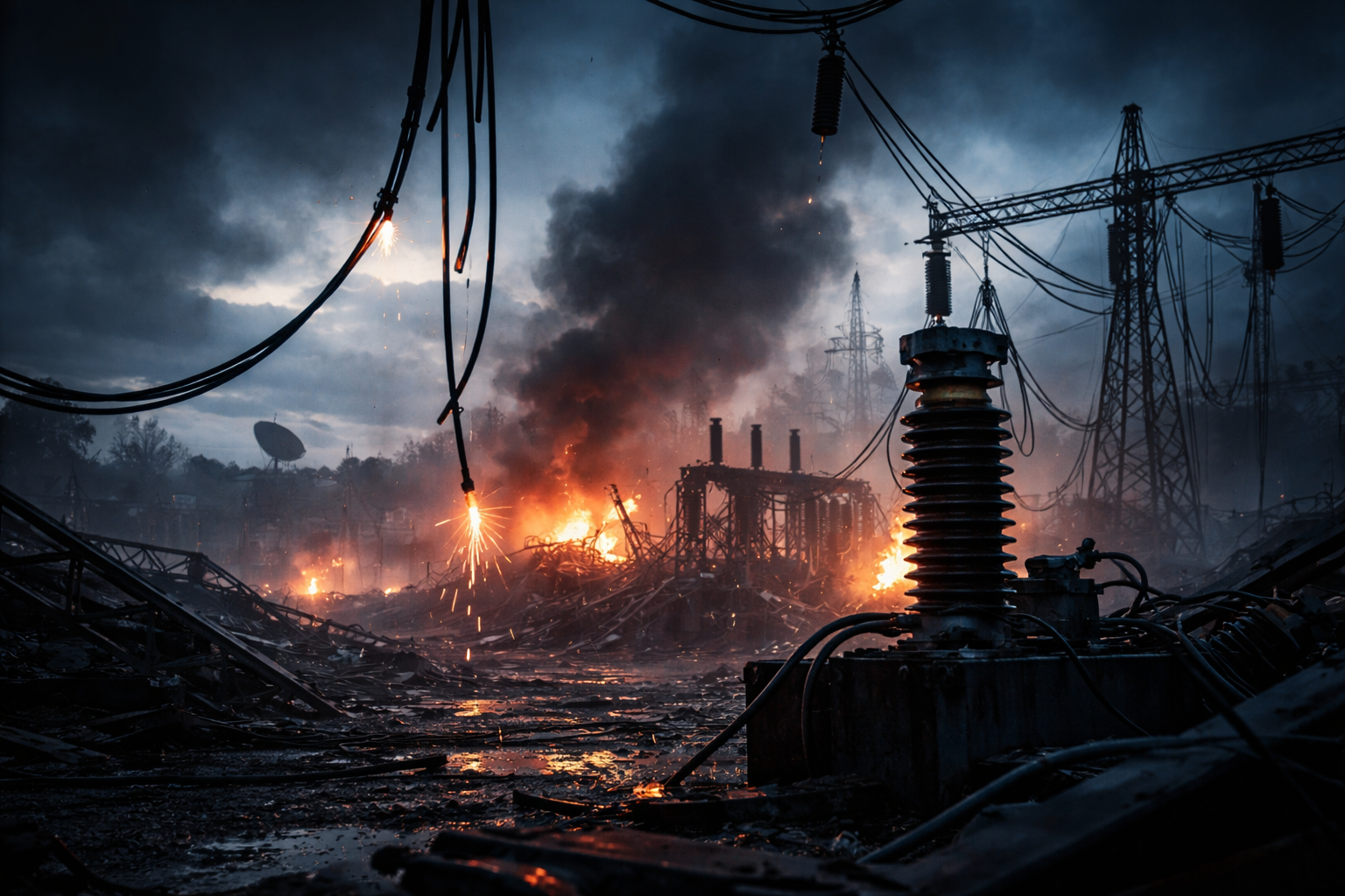
Zaporizhzhia is both a frontline-adjacent region and a critical node in Ukraine’s industrial and energy geography.
That combination creates an enduring tension: strikes there can have civilian consequences even when the military intent is disputed.
“Infrastructure” is not one thing. It can mean power distribution, water and heating systems, rail lines, telecoms, fuel storage, industrial facilities, or municipal buildings. Each category leaves different forensic traces.
On high-attention days, the information environment changes. More claims surface, more cameras point in the same direction, and more actors benefit from shaping perception quickly. That does not make any one claim false. It makes early certainty expensive.
The first constraint: claims spread faster than coordinates
The earliest layer of information is usually an official statement: that a strike happened, that damage occurred, and that response teams are working.
That layer is important, but it is not the final layer. Early statements rarely include precise coordinates, technical failure modes, or independent measurements. They are designed to inform and to warn, not to complete an evidence record.
In fast live coverage, the public often treats “reported” as “proven.” That is the first verification trap.
Competing models: strike damage vs secondary effects vs misattribution risk
When “infrastructure damage” is reported, there are several plausible models that can fit the same early facts.
One model is direct impact: a munition hits an infrastructure site and damages equipment or structures.
A second model is secondary damage: a nearby impact breaks lines, shatters windows, knocks out transformers, or triggers fires that spread.
A third model is cascading outage: a strike or air-defense intercept leads to grid instability, which forces controlled shutdowns that look like damage from the outside.
A fourth model is misattribution: an image is real but from a different time or place, or the reported target category is overly broad. This is common in fast cycles because old footage is plentiful and labels travel faster than checks.
The verification goal is not to pick a model by intuition. It is to test which model fits the evidence as it arrives.
The hinge problem: why “infrastructure” is hard to prove quickly
Infrastructure is difficult to verify quickly because the best evidence is often non-visual.
A blown substation does not always look cinematic, but it can leave a very specific pattern: localized outages, repeated switching events, repair crew movements, and consistent reporting from utilities and municipal services.
Meanwhile, the most shareable visuals often show the least identifying detail: smoke against a dark sky, a flash on the horizon, generic debris, or a street-level shot with no unique landmarks.
That creates a mismatch between what spreads and what proves.
The verification ladder: what would confirm next, step by step
Step one is consistent official reporting. If multiple officials or agencies describe the same event window and general location without contradicting each other, that raises baseline credibility while still stopping short of proof.
Step two is time anchoring. Look for a clear local-time window and sequence: sirens, impacts, emergency response, and follow-up warnings. A tight timeline reduces the chance that unrelated footage is being reused.
Step three is geolocation cues. The most valuable imagery is not the most dramatic; it is the most place-specific. Useful cues include distinct skylines, road layouts, signage, unique building shapes, rail junctions, bridges, pylons, and facility perimeter features.
Step four is target-type corroboration. If the claim is “energy infrastructure,” you would expect supporting signals such as local outage notices, municipal service interruptions, and repair statements that match the same geography.
Step five is satellite and aerial patterning. In daylight, high-resolution imagery can show burn scars, roof damage, crater patterns, destroyed transformers, or disrupted rail lines. Repeated passes matter more than one image because they show change over time.
Step six is durable records: official incident reports, repair timelines, and independent documentation that remain consistent as the news cycle moves on.
Each step narrows uncertainty. The mistake is skipping steps because the headline feels urgent.
The truth stack: how to layer statements, cues, satellites, and timelines
A “truth stack” is not a single proof point. It is a structured pile of independent supports.
Start with official statements as the top layer of intent and immediate effects. Treat it as “credible but unconfirmed” until it has place-and-time anchors.
Add geolocation cues as the next layer. If imagery can be pinned to a specific neighborhood or facility perimeter, the claim becomes testable rather than rhetorical.
Add systems-level expectations. If an energy site was hit, you should see downstream effects that match the geography: outages, controlled shutdowns, restoration updates, and repair activity. If those effects do not appear, the claim may be mis-specified or limited in scale.
Add satellite or repeat imagery expectations. Infrastructure damage often becomes clearer in daylight and after emergency response stabilizes a scene. A lag is normal. The absence of immediate high-quality imagery is not proof of absence.
Finally, lock the timeline. The strongest truth stacks give you a sequence you can recheck: what happened first, what happened next, and what evidence arrived at each stage.
This approach keeps you honest when the incentives reward speed.
What Most Coverage Misses
The hinge is that infrastructure strike verification often becomes reliable first through grid and service signals, not through viral footage.
That mechanism matters because grid telemetry, outage notices, and restoration updates create time-stamped, geographically bounded evidence that is harder to recycle from older incidents. It shifts the story from “who says what” to “what changed in the system.”
Two signposts can confirm these facts quickly: a consistent pattern of local outages and restoration activity that matches the reported area, and daylight imagery that shows physical damage consistent with the same timeline.
What Happens Next
The story will tighten as more specific evidence arrives, because high-attention events produce both more documentation and more pressure to correct errors.
In the short term, watch for official clarifications that narrow the claim from “infrastructure” to a named category, because specificity is a constraint that makes later contradiction harder.
In the longer term, the stakes are about trust and resilience, because repeated uncertainty cycles change how audiences interpret future warnings. If early claims repeatedly outpace proof, people discount real alerts. If early claims are carefully bounded, the information channel stays credible.
The key decisions and events to watch are simple: whether authorities provide more precise location and category details, whether utilities and municipal services report matching disruptions and restoration, and whether daylight imagery supports the same time-and-place record.
Real-World Impact
A family in a city district near reported impacts may spend the day managing heating, water, and phone charging, regardless of what the target was meant to be.
A small business can lose inventory and income from even short power interruptions, especially if refrigeration or payment systems fail.
Rail and logistics delays can ripple outward, even when damage is local, because rerouting and safety checks slow movement.
Emergency services encounter a challenge in their operations: they must respond quickly while maintaining a clean record for future audits.
When the record becomes durable
The core dilemma is not only military. It is informational. Speed helps safety, but speed can also harden mistakes.
Whether the evidence stack grows in a disciplined manner or treats early fragments like conclusions is a crucial decision point.
Watch for the durable signposts: consistent timelines across official updates, place-specific imagery that can be re-checked, and system signals like outages and restoration that match the same geography.
How this data gets verified will shape the credibility of the next warning, and that is historically significant in a war where information moves as fast as explosives.