

Brazil’s Cerrado Is Quietly Breaking—And the World’s Food System Is Exposed
A review suggests over half of the Cerrado’s native vegetation is gone. Why it matters now: water-cycle feedback, fire risk, and food impacts.
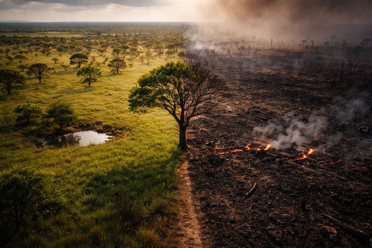
The Cerrado Tipping Point: Why “55% Lost” Changes Everything
A newly published review has circulated a stark headline claim: more than 55% of the Cerrado’s native vegetation has been lost. The phrase is doing a lot of work. It can read like “half the Cerrado is gone,” which is not quite what it means—and yet the underlying signal is still severe.
The most careful interpretation is narrower and more specific: the figure is about the loss or conversion of native vegetation cover (the natural mosaic of grasslands, savannas, and forest patches), not that 55% of Brazil’s landmass—or even 55% of the Cerrado’s mapped administrative footprint—has literally disappeared. In practice, it points to a long-run transformation of ecological function: roots replaced by plows, seasonal wetlands drained or fragmented, and fire regimes pushed out of balance.
The global relevance is not only biodiversity. The Cerrado matters because it behaves like a systems stabilizer—for water, for climate, and for commodity reliability. When you remove enough native vegetation from a seasonal landscape, you don’t just lose species. You change the physics of heat, moisture, and combustion.
One sentence explains why the “55%” claim is such a hinge: in a water-limited system, vegetation is not decoration—it is infrastructure.
The story turns on whether the Cerrado can absorb further conversion without flipping into a hotter, drier, more fire-driven state that reshapes rainfall and food security beyond Brazil.
Key Points
A recent review claims more than 55% of the Cerrado’s native vegetation has been lost/converted; the most defensible reading is loss of native cover, not “55% of total land area vanishing.”
The Cerrado is globally important because it helps regulate water cycling (infiltration, baseflow, and evapotranspiration), which underpins both ecosystems and large-scale agriculture.
Vegetation loss can trigger feedback loops: hotter surfaces → drier air → weaker local rainfall → longer dry seasons → more fire → further degradation.
Fire risk is not just “more burning.” It is a regime shift: repeated, human-driven fire can simplify vegetation and erode recovery capacity.
Carbon impacts are not confined to trees; the Cerrado stores a substantial share of its carbon belowground, so degradation can release carbon even when the landscape looks “not forested.”
Measurement has real uncertainty: “native vegetation,” “loss,” and “conversion” vary by method and definition. The direction is clear; the exact percentage is the debated edge.
Policy and market levers exist: conversion-free supply chains, enforcement of land-use rules, targeted protection of hydrologically critical areas, and finance that rewards keeping native cover standing.
Background
The Cerrado is a vast tropical savanna region, but “savanna” undersells it. It is a patchwork: open grasslands, shrublands, wooded savannas, gallery forests along rivers, and wetland systems that behave like sponges in the rainy season and lifelines in the dry season.
That mosaic matters because the Cerrado is strongly seasonal. In seasonal landscapes, the difference between stability and breakdown is often the dry season—how long it lasts, how intense it becomes, and whether vegetation can bridge it without collapsing into repeated burn-and-regrow cycles that get poorer each time.
Land conversion in the Cerrado has been driven largely by agricultural expansion and associated infrastructure—roads, storage, processing, irrigation, and settlement. The result is not only outright clearance. It is fragmentation, altered fire patterns, and changes to water flows that are not always captured by simple “forest/non-forest” thinking.
The “more than 55% lost” claim sits in this context. It compresses decades of land-use change into a single number. The risk is that readers treat it as a moral headline rather than what it really is: a systems signal.
Analysis
What “55% lost” most likely represents
A key point of discipline: the claim is best understood as loss or conversion of native vegetation cover relative to an earlier baseline, not that the Cerrado’s geographic footprint has shrunk by 55%. “Native vegetation” in the Cerrado includes non-forest types that can be mistakenly treated as “empty” or “already degraded” from a distance. That makes the choice of definitions and remote-sensing categories unusually consequential.
Confirmed: the review’s claim exists and is framed as native vegetation already converted/lost rather than a statement about administrative land area.
Disputed/unclear: the exact percentage depends on the baseline year, what counts as “native,” how secondary regrowth is classified, and whether “degraded but present” is counted as loss.
Unknown: how close the system is to a single “tipping point” number. Seasonal ecosystems often do not flip everywhere at once. They tip in patches, then spread via water and fire feedbacks.
The useful way to read the “55%” is therefore not as a precise measurement to the decimal point but as a warning that the remaining native mosaic may be nearing a functional threshold—particularly in water-sensitive subregions.
The water-cycle feedback loop that turns local loss into global risk
Mainstream coverage tends to stop at “habitat loss.” The deeper mechanism is water.
Native Cerrado vegetation is built for seasonality. Deep roots, porous soils, and intact wetland mosaics promote infiltration during rains and sustain baseflow (the slow release of groundwater to streams) in dry periods. When native cover is replaced with simplified vegetation or exposed soil, several things tend to move in the wrong direction at once:
The surface heats faster. Hotter surfaces raise evaporative demand—the atmosphere’s “thirst.” Plants then need more water to keep transpiring, but the system often has less available.
Rain becomes harder to “recycle.” A portion of rainfall is re-emitted back into the atmosphere through evapotranspiration. If that recycling weakens, downwind areas can become drier, and the dry season can lengthen.
Runoff spikes while recharge falls. With less infiltration and altered soil structure, more water runs off quickly during storms instead of refilling subsoil moisture and aquifers.
None of these effects require complete clearance to matter. Fragmentation and repeated burning can lower hydrologic function while maps still show “vegetation.”
Confirmed: vegetation affects local energy balance and moisture cycling; this is basic land–atmosphere physics.
Disputed/unclear: the magnitude of rainfall change attributable to Cerrado conversion alone versus wider climate variability and land-use change elsewhere.
Unknown: whether there is a sharp threshold after which regional rainfall reorganizes abruptly or a smoother decline with occasional step-changes during drought years.
Fire dynamics: when “more ignitions” becomes a new regime
Fire is often described as natural in savannas, which is partly true. But there is a major difference between ecologically patterned fire and chronic, human-driven fire pressure.
In a stable regime, fires tend to occur in patterns that many native species can tolerate. In an unstable regime, fires become too frequent, too extensive, or too late in the dry season, when vegetation is most flammable. That changes the species mix: fire-sensitive components shrink, flammable grasses can expand, and the system can lock into a “burnable” state.
Vegetation loss pushes fire risk up through several channels at once:
Drier microclimates emerge along edges and cleared areas.
Fuel structure changes—simplified landscapes can carry fire differently than heterogeneous mosaics.
Suppression and ignition both rise near roads and farms: more people means more ignition sources, and suppression is not always effective across large areas.
Confirmed: repeated, poorly timed fires can reduce ecosystem complexity and recovery capacity.
Disputed/unclear: the point at which fire becomes self-reinforcing across the Cerrado as a whole, rather than in vulnerable subregions.
Unknown: how future governance, enforcement, and land management will shape ignition rates relative to climate-driven drying.
Carbon: the “invisible” emissions problem below the surface
The Cerrado is often misframed as “less carbon than a rainforest,” which misses the structure of where its carbon sits. Much of the system’s carbon is stored belowground: roots, soils, and wetland-adjacent organic matter that can be destabilized by drainage, plowing, erosion, and repeated high-intensity burning.
That matters for three reasons.
First, belowground carbon loss can be large even when satellite imagery still shows vegetation. Degradation can be a carbon story without looking like deforestation.
Second, carbon loss interacts with water loss. Drying and soil disturbance can accelerate decomposition and reduce the landscape’s capacity to buffer drought.
Third, the emissions profile can be episodic: drought years and major fire seasons can release large pulses, which then push heat and aridity further.
Confirmed: soil and belowground carbon are central to Cerrado function; disturbance can release carbon and reduce resilience.
Disputed/unclear: how much carbon is released per unit of conversion varies widely with soil type, land management, and whether wetlands are affected.
Unknown: whether carbon–fire–water feedbacks will produce a long-term upward ratchet (each drought year leaving the system more flammable than before).
Science, evidence, and measurement traps
The most important honesty in this debate is that “native vegetation loss” is hard to measure perfectly in a savanna mosaic.
One trap is classification. Savannas and grasslands can look “already open” compared to forests, yet they are native and functional. If monitoring systems emphasize forest loss, they can miss conversion of non-forest native vegetation—or treat it as a lower priority.
A second trap is the definition of “loss.” A landscape can retain vegetation cover while losing its ecological function through fragmentation, invasive grasses, repeated fire, soil compaction, or altered hydrology. That is not always counted as “lost,” but it can behave like loss.
A third trap is baseline choice. “More than 55% lost” implies a reference point—an earlier state of the biome. Different datasets choose different historical baselines and interpret regrowth differently.
Confirmed: measurement depends on definitions (native vs non-native, loss vs degradation, baseline selection).
Disputed/unclear: the exact percentage figure and how comparable it is across studies.
Unknown: the true extent of functional degradation that does not register as conversion in land-cover maps.
What Most Coverage Misses
The hinge is simple: in the Cerrado, land conversion is a water-cycle shock with economic consequences, not only an ecological one.
The mechanism is that removing native vegetation changes heat and moisture flows. That can lengthen dry seasons, raise irrigation dependence, increase fire risk, and ultimately introduce volatility into the production of crops and livestock that global supply chains treat as reliable. In other words, this is not just “Brazil’s biodiversity story.” It is a food and inflation story for any market exposed to soy, beef, animal feed, and bio-based inputs.
Two signposts would confirm this framing in the next months and years. First, persistent shifts in dry-season river flows and groundwater stress in Cerrado-dependent basins, especially where irrigation is expanding. Second, evidence that drought and fire years are not just bad “weather years” but are leaving a lasting footprint—reduced vegetation recovery, more frequent burns, and rising dependence on irrigation to maintain yields.
Why This Matters
In the short term, the biggest risk is not that global markets suddenly “run out” of Cerrado-linked commodities. It is that production becomes more variable—more sensitive to drought years, more dependent on irrigation and inputs, and more exposed to regulatory and reputational shocks.
In the longer term, the risk is structural. If vegetation loss pushes the Cerrado toward a hotter, drier regime, agriculture can enter a feedback loop: lower rainfall reliability encourages more irrigation and new water infrastructure; that further stresses hydrology; stressed hydrology amplifies drought impacts; drought impacts raise fire risk; fire risk degrades native vegetation and soils; degraded soils and vegetation reduce water buffering even more.
This matters globally because Brazil is a cornerstone supplier across multiple commodity chains. When a cornerstone supplier becomes climatically less stable, price shocks travel. Food costs, feed costs, and input costs do not stay local.
Policies can change the trajectory because the driver is not mysterious—it is incentives.
Stronger enforcement of land-use rules can reduce “legal but high-impact” conversion and push expansion toward already-cleared or degraded land.
Conversion-free procurement standards can close the loophole where “deforestation-free” still allows conversion of savannas and grasslands.
Finance and insurance can price land-conversion risk directly: cheaper capital for farms and traders that demonstrate verified conversion-free sourcing, and higher costs for those that do not.
Targeted protection for hydrologically critical landscapes—wetlands, headwaters, recharge zones—can preserve water function even where full-scale protection is politically difficult.
The key “because” line is this: because water cycling is the limiting factor in a seasonal biome, protecting native vegetation is a form of infrastructure investment in rainfall stability and food security.
Real-World Impact
A grain buyer faces a new kind of due diligence problem. “No deforestation” is no longer sufficient to manage risk if conversion continues in non-forest ecosystems. Compliance becomes harder, and procurement becomes more exposed to sudden rule changes.
A food manufacturer experiences cost volatility. Feed prices jump after drought and fire seasons, then settle, then jump again. Forecasting becomes less reliable, and hedging costs rise.
A regional utility or municipality confronts water uncertainty. Reservoir planning becomes harder when baseflow weakens, storms become flashier, and dry spells stretch. The costs show up in tariffs, restrictions, and emergency projects.
A farm operation adapts defensively. More irrigation, more soil amendments, more firebreaks, and more dependence on inputs to stabilize yields. Profitability becomes more sensitive to interest rates and to policy shifts.
The Evidence That Would Prove a Tipping Point Is Near
The Cerrado does not need a single dramatic “flip” to create global consequences. But if readers want a serious evidence standard for a tipping point, it would look like this.
First, consistent hydrologic change: multi-year declines in dry-season flows and groundwater conditions in key Cerrado-fed basins that cannot be explained by short-term variability alone.
Second, atmospheric signals: detectable shifts in evapotranspiration, surface temperature, and rainfall seasonality that align spatially with conversion intensity and that persist across different datasets.
Third, ecological lock-in: more frequent reburning, poorer vegetation recovery, and a shift toward more flammable, simplified vegetation that makes future fires easier to spread.
Fourth, economic dependence: rising irrigation dependence and water conflict indicators that track with land conversion and drought years, signaling that agriculture is compensating for lost ecosystem function.
If those signposts accumulate, then “55% lost” stops being a headline and becomes a threshold marker: evidence that the Cerrado is no longer buffering climate variability—it is amplifying it.
The historical significance is not only what has been converted, but also what the remaining landscape is still doing for the planet—and what happens if it stops.